Precision Navigation & Route Planning

Plan fishing trips from home with routes, distance tracking, shareable waypoints, and on-water map context

Create and navigate fishing routes
Decision guide

Decide whether the route is ready before the boat leaves.

Navigation copy should frame Fish Fathom as a planning workflow: map evidence, waypoints, route distance, offline readiness, and safety checks in the right order.

priority_high

Problem

Routes built in a hurry on the water waste fuel and attention. The better decision is whether the plan is specific enough to run before service, weather, or crew time becomes the constraint.

verified

Proof

Fish Fathom ties route creation, distance context, saved waypoints, downloaded maps, GPS position, and shareable marks to the same fishing map workflow.

route

Workflow

Download the area, study the map layers, mark the stops, connect them into a route, check distance and fuel reality, then run the route while keeping required navigation equipment available.

report

Limits

Device GPS accuracy varies, fresh connected layers can require service, and Fish Fathom is not a substitute for official charts, required navigation gear, safety equipment, or local judgment.

Plan the full tripConnect route planning with target, weather, and private history.Download the areaPrepare map context before cell service drops.Organize waypointsMake route stops easier to name, filter, and share.

Plan Your Fishing Trip from Home

Imagine planning your entire fishing expedition from the cozy comfort of your living room. With Fish Fathom, you can easily plot waypoints and routes in advance, ensuring that you're fully prepared for your day on the water.

This feature allows you to strategically plan your trip by marking your favorite fishing spots, safe navigation routes, and any points of interest you want to explore. Study the charts, identify structure, plan fuel stops, and map out your day - all before you leave the dock.

This not only saves you time on the water but also enhances your overall fishing experience by providing a well-organized plan. You're not wasting expensive boat hours figuring out where to go. You arrive with a strategy.

Trip Planner Flow

cloud_download

Download Your Area

Save charts and supported HD Bathymetry for your fishing grounds before you leave the dock.

map

Study the Charts

Review structure, depth changes, channels, and safe approaches while you are still planning at home.

location_on

Mark Waypoints

Save fishing spots, hazards, fuel stops, and the marina so the full day has clear anchor points.

ios_share

Share Waypoints

Send selected waypoint files through AirDrop on Apple devices, Quick Share on Android, messages, or email.

route

Create Routes

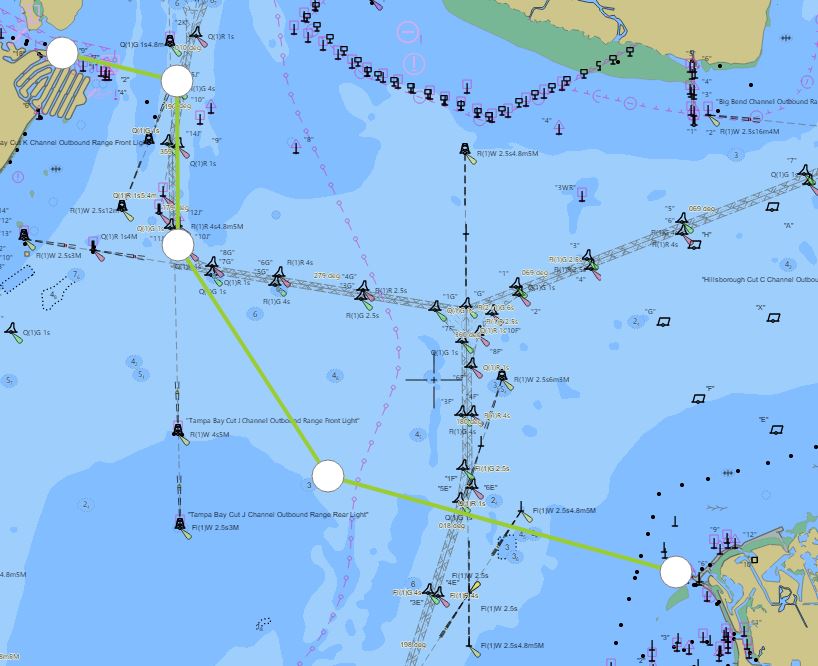
Draw multi-point routes connecting waypoints. Plan your entire day: dock → spot 1 → spot 2 → fuel → dock.

edit

Edit Routes

Add waypoints, reorder stops, or delete segments. Modify routes on the fly as conditions change.

navigation

Turn-by-Turn Navigation

Active route guidance with distance and bearing to the next waypoint so the next leg stays visible.

straighten

Distance Monitoring

See total route distance, distance to next waypoint, and distance remaining. Plan fuel accordingly.

speed

Speed & ETA

Current speed, average speed, and estimated time of arrival to waypoints and final destination.

gps_fixed

Course Tracking

See your current course vs planned route. Instant visual feedback if you drift off course.

explore

Course Up / North Up

Choose map orientation: Course Up (map rotates with heading) or North Up (traditional orientation).

settings

Unit Preferences

Display distances in nautical miles, statute miles, or kilometers. Speed in knots, mph, or km/h.

all_inclusive

Unlimited Routes

Create as many routes as you want. Save routes for different fishing areas or seasons.

How to Plan a Fishing Route

1

Download Maps

Save charts and supported map layers for the area you plan to fish while you still have a strong connection.

→
2

Study the Charts

Review NOAA charts and HD Bathymetry where supported to identify structure, depth ranges, and potential fishing spots.

→
3

Mark Waypoints

Create waypoints for fishing spots, navigation hazards, fuel stops, and the marina departure/return point.

→
4

Connect the Dots

Create a route connecting waypoints in the order you want to visit them. The app calculates total distance.

→
5

Navigate

Activate the route on the water and follow your planned path from waypoint to waypoint.

GPS Accuracy & Tracking

High-Precision GPS

Fish Fathom uses your device's GPS chip for accurate position tracking. Typical accuracy: 5-15 meters under open sky.

Real-Time Position

Your position updates on the map so you can compare your track against saved waypoints and routes.

Heading & Course

Visual compass and heading display. Know which direction you're pointed and which direction you need to go.

Works Offline

GPS tracking and navigation work offline with downloaded maps. Fresh SST, Plankton/chlorophyll, Captain Brad AI, and connected recommendations still require internet.

Real-World Use Cases

Offshore Fishing Trip

Plan a route from the marina to multiple offshore ledges 60 miles out. Calculate total distance (120+ miles round trip), estimate fuel needs, and add waypoints for safe navigation through shipping channels.

Nearshore Reef Hopping

Create a route hitting 5-6 nearshore reefs in one day. Optimize the order to minimize travel time and maximize fishing time at productive spots.

Tournament Strategy

Pre-plan multiple routes based on weather forecasts. If winds are from the south, use Route A. If winds shift north, activate Route B. Be ready for any conditions.

New Area Exploration

Exploring a new fishing area? Create a route connecting promising structure you identified on charts. Systematically check each spot without getting lost.

Benefits of Route Navigation

  • ✓
    Save Time: Pre-planned routes mean less time searching and more time fishing
  • ✓
    Save Fuel: Optimize route order to minimize travel distance and fuel consumption
  • ✓
    Safety: Plan safe routes avoiding hazards and shallow water before you leave the dock
  • ✓
    Trip Context: Keep your planned route, waypoints, and distance context visible while you run
  • ✓
    Maximize Fishing Time: Less navigation time = more time with lines in the water

Ready to Navigate Like a Pro?

Plan your routes and fish with precision.

Download for iOS Download for Android